Hoye Crest
Maryland

Last Updated 31 Jan 2026
Hoye Crest is the highest point in Maryland, making it a popular destination for state highpointers. Despite its prominence, Hoye Crest offers a relatively easy hike with rewarding views at the summit, making it an enjoyable experience for hikers of all levels.
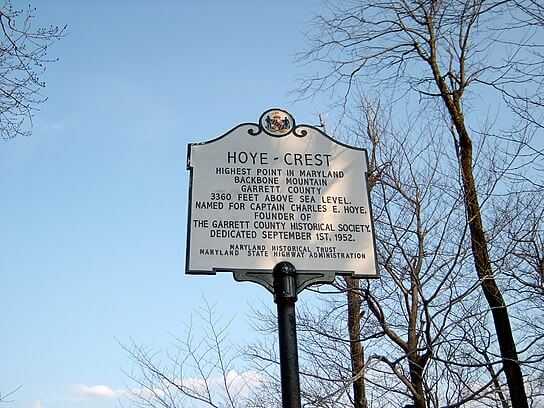
Hoye Crest holds a special place in Maryland's geography and history. The mountain is part of the Appalachian Mountains and spans the Maryland and West Virginia border. The area is known for its rich natural beauty and has been a site for various outdoor activities. A commemorative sign marks the summit, and recent efforts to clear some trees have improved the views from the top. Additionally, nearby attractions, such as the smallest church in the lower 48 states in Silver Lake, West Virginia, add a touch of local charm to the visit.
Access Point
Navigate to 6GW5+67 Eglon, West Virginia.
To reach the trailhead for Hoye Crest from I-68, take Exit 14 and head south on US 219. After passing the junction with US 50 at Redhouse, Maryland, continue for 4.3 miles until you arrive in the village of Silver Lake, West Virginia. From there, continue south on US 219 for another 1.1 miles. Watch for trees with orange blazes on the left side of the road and a small sign marked "MD HP"—this indicates the trailhead. Parking is available on both sides of the road. Do not attempt to drive up the logging road, as it is rough and may be legally restricted.
Recommended Route
Start at the Backbone Mountain Trailhead.
From the roadside trailhead, begin hiking up the logging road. The hike takes about 20 minutes. Be sure you are following the route marked "MD HP," as multiple old logging roads in the area also have orange blazes and can be confusing. Do not rely solely on the orange blazes—look instead for red “HP” markings on trees to stay on the correct trail. Along the way, you’ll pass several red wooden signs reading "Highpoint, MD/WV Marker."
After approximately 0.75 miles, take a left onto a narrow footpath that branches off the logging road. The trail runs parallel to a metal fence bordering a private farm on your left as you climb.
Near the top, the path briefly splits: the grassy path to the right and the rocky path to the left both lead to the same point and rejoin shortly before the summit.
At the summit, you’ll find a sign marking Maryland’s highest point, a cleared area offering views to the east, and a picnic table. Rest and enjoy the scenery!
The hike is about 1 mile round-trip with a 700-foot elevation gain.
Regulations
The summit and the immediate area are on private property owned by a coal company. Stay on the trail, avoid littering or camping, and respect the landowner's rights.
Lodging & Camping
The nearby Monongahela National Forest in West Virginia offers camping opportunities. For a more developed camping experience, Blackwater Falls State Park, located about ten miles south in West Virginia, provides numerous campsites, hiking trails, and waterfalls to explore.
FAQs
What is the best time of year to visit Hoye Crest?
The best time to visit Hoye Crest is from late spring to early fall when the weather is mild and the trails are clear. Winter can bring snow and ice, making the hike more challenging.
Do I need a permit or pay a fee to hike Hoye Crest?
No permits or fees are required to hike Hoye Crest. However, the trail crosses private property, so please respect the landowners' wishes and maintain good behavior.
How is cell service at Hoye Crest?
Cellular service is poor around Backbone Mountain, and hikers report no reception on the trail. Make sure to download your maps for offline use before heading out.
Is the trail to Hoye Crest well-marked?
The trail to Hoye Crest is marked with red, wooden signs to guide hikers to the summit.
Are there restroom facilities at Hoye Crest?
Hoye Crest has no restroom facilities, so plan accordingly before your visit.
Is camping allowed at Hoye Crest?
Camping is not permitted on the summit or the surrounding private property. Nearby Monongahela National Forest and Blackwater Falls State Park in West Virginia offer camping options.
Is Hoye Crest suitable for children and older adults?
The trail to Hoye Crest is relatively easy and suitable for hikers of all ages, including children and older adults.
Acknowledgements
Thank you to Bill Pucci of Holland, MA for updated route information.
