Borah Peak
Idaho

Last Updated 31 Jan 2026
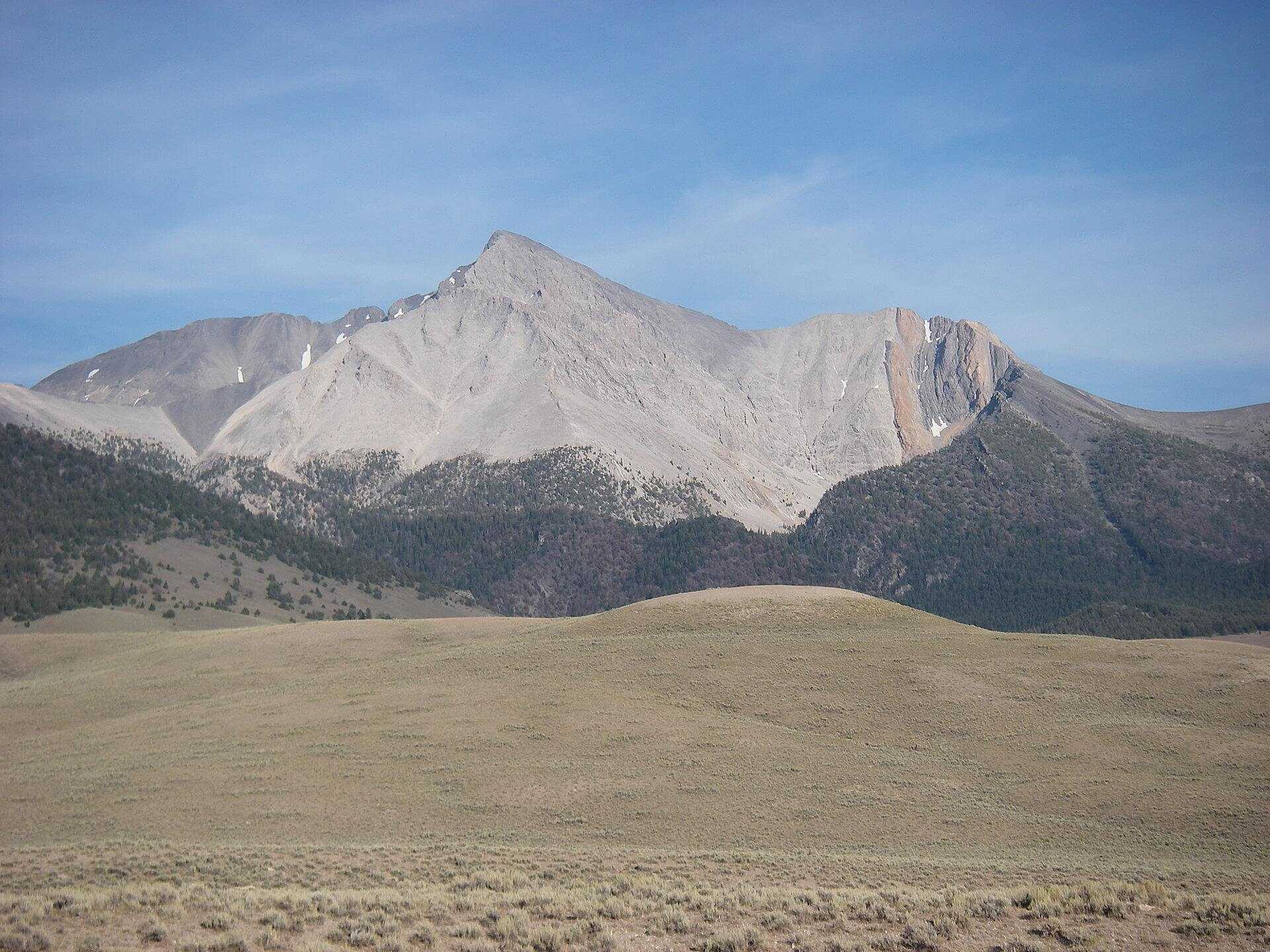
The pride of Idaho! At 12,662 feet, Borah Peak, locally known as Mount Borah, is the highest mountain in Idaho and the monarch of the Lost River Range. With nearly 6,000 feet of prominence, it is one of the rare and prized ultra-prominence peaks. The standard route, Chickenout Ridge, is a semi-exposed third-class scramble in late summer but can become an all-out mountaineering adventure with a narrow snow knife-edge ridge walk early in the season. The peak consists of bare grey limestone, with similar grey peaks surrounding it, and offers stunning views of the low rolling valleys and snow-covered peaks beyond.
Borah Peak was first climbed in 1912 by T. M. Bannon, a USGS surveyor, and was named in 1934 for state senator William Borah, "The Lion of Idaho," who ran in the presidential election in 1936. A massive earthquake on October 28, 1983, caused the summit to rise seven feet, potentially making its actual elevation higher than many maps indicate.
Most people complete the climb in a single day. The scramble on Chickenout Ridge is the most renowned feature of any route in Idaho. Many hikers have returned with the unfortunate tale of turning back at this crux. Listening to your instincts and knowing when to turn around for safety is crucial. Additionally, numerous technical routes are on various sides of the mountain for more advanced climbers.
Access Point
Navigate to 45M8+26 Mackay, Idaho.
To reach Borah Peak from Mackay, take U.S. Highway 93 north for 21 miles to the Borah Peak Access Road (Birch Springs Road) between mileposts 129 and 130. Follow this road east for 3 miles to the trailhead.
From Challis, take U.S. Highway 93 south for 33 miles to the Borah Peak Access Road. Follow this road east for 3 miles to the trailhead. In good weather, the road is suitable for most passenger cars. The trailhead is unmarked but evident from the parking area and starts on the uphill side (east) of the lot.
From Ketchum/Sun Valley (Highway 75), take Trail Creek Road, one of Idaho's most scenic backcountry roads. It is a 50-mile drive to the base of Mount Borah. The gravel section of this road can be smooth after grading but can become rough and challenging later. This seasonal road closes in late fall and reopens in the spring after plowing. You can shorten the drive by turning north on the Chilly shortcut before reaching Highway 93.
Recommended Route
Follow the Mount Borah Southwest Ridge Trail.
Starting at Birch Springs, follow the trail east through pine forest and sagebrush. Although there are minor switchbacks, the trail remains steep and gains the crest of the southwest ridge at 8,600 feet. Trees thin out above 9,500 feet. At 11,200 feet, you reach the crux scramble section of Chickenout Ridge. Those uncomfortable with exposure should consider turning back here.
Choose the line of least resistance, with options on either side of the ridge or the spine. The rock is generally solid. After the scramble section, a steep step down to a narrow ridge features a snow knife edge early in the season. Beyond this, the trail continues, bypassing a high point on the ridge, and regains the crest at 11,750 feet.
The final southwest slope consists of bare slabs, ledges, scree, and talus. Ascend in a northerly direction, careful not to dislodge rocks onto others. There is a summit register as of June 2014. Please avoid leaving trash or trinkets on the summit.
Regulations
Borah Peak resides in the Challis National Forest and requires no hiking permits or fees.
Lodging & Camping
There are several nice campsites near the trailhead, with a toilet but no water. The elevation is 7,200 feet, so it can get cold at night. Camping at the trailhead campground requires a $5 fee per night.
FAQs
What is the best time of year to hike Borah Peak?
The best time to hike Borah Peak is from late June to early September when the snow has melted and the trail conditions are optimal. Early in the season, the trail can be covered in snow, making the hike more challenging and requiring mountaineering skills.
How long does it take to hike Borah Peak?
The round-trip hike typically takes 7 to 12 hours, depending on your fitness level, pace, and weather conditions.
Do I need a permit to hike Borah Peak?
No permits are required to hike Borah Peak.
What should I bring for the hike?
Bring plenty of water, high-energy snacks, appropriate clothing for changing weather conditions, a map or GPS device, a first aid kit, and sun protection. Hiking poles can also be helpful for the steep and rocky sections.
Is Chickenout Ridge as scary as it sounds?
Chickenout Ridge can be intimidating for those unfamiliar with exposure, but experienced mountaineers find it manageable.
Can I drive to the trailhead in a regular car?
Yes, the road to the trailhead is suitable for most passenger cars in good weather. However, the road conditions can vary, so it's best to check ahead, especially after heavy rains.
Are there restroom facilities at the trailhead?
Yes, a toilet is available at the trailhead, but there is no water, so plan accordingly.
Can I camp at the trailhead?
Yes, there are several campsites available near the trailhead. Camping here requires a $5 fee.
What should I do if I experience altitude sickness?
If you experience symptoms of altitude sickness, such as headaches, dizziness, or nausea, descend to a lower elevation immediately and seek medical attention if necessary. Acclimatizing at the trailhead before the hike can help prevent altitude sickness.
